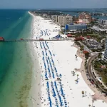
The closest beach to Monterrey is Playa Bagdad, a long stretch of Gulf of Mexico sand east of Matamoros in the state of Tamaulipas. It sits roughly 220 miles (about 355 km) from Monterrey, and the drive usually takes around 4 hours on toll highways .

Find Your Ideal Stay in Monterrey on Vrbo

Search extensive private home inventory, review verified guest feedback, and book your trip
with complete confidence.

Monterrey itself has no beach. The city sits inland in Nuevo León, a state with no coastline, so every beach day starts with a long drive or a flight. That matters more than the distance: the nearest Mexican beaches are all in Tamaulipas, which carries the highest-level U.S. government travel warning.

This page covers the closest beach, how to get there, what to know about safety before you go, and the easier beach options many travelers pick instead, from the Texas coast to a short flight to the best beaches in Mexico.

Does Monterrey Have a Beach?

No. Monterrey is an inland city in the Sierra Madre Oriental foothills, and Nuevo León is landlocked. The nearest coastline is the Gulf of Mexico in neighboring Tamaulipas, to the east. You may see “Playa Costa Azul” and similar names on maps of Monterrey, but those are street or neighborhood names inside the city, not beaches.

Monterrey is also on Mexico’s Gulf (east) side, not the Pacific. The Pacific coast is much farther away, so most beach trips from Monterrey head toward the Gulf or go by plane.

How Far Is Monterrey from the Ocean?

The nearest stretch of ocean is about 220 miles (355 km) away at Playa Bagdad, roughly a 4-hour drive . It’s the closest beach by a clear margin, but it sits under the same state-level travel advisory as every other Tamaulipas beach.

Farther south in Tamaulipas, the fishing town of La Pesca takes about 5 to 6 hours by car, and Playa Miramar in Tampico and Ciudad Madero is about 300 miles (500 km) away, or 6 to 7 hours on the road. Miramar has more hotels and services than the other two, but all three share the same advisory.

South Padre Island in Texas is a similar distance to Playa Bagdad, though border waits can add hours and you’ll need U.S. entry documents. For a full beach vacation rather than a day trip, a short direct flight from Monterrey to Cancún or Los Cabos is often the easiest option.

All distances and times here are approximate and change with traffic, border waits, and road work, so check them in a live map app before you leave.

Playa Bagdad at a Glance

Playa Bagdad is officially named Playa Lauro Villar, but most people, road signs, and maps still use the older name . It’s the main beach for Matamoros residents and the closest coastline to Monterrey.

The beach is a wide, flat, sandy stretch of Gulf shoreline. Access has traditionally been free, though parking, palapas, and chairs may cost extra . Seafood stands and palapas cluster near the main access road, with few services elsewhere . It gets busiest during Semana Santa and on summer weekends.

How to Get from Monterrey to Playa Bagdad

Driving is the most direct way to reach the closest beach to Monterrey. Public transport works but takes most of the day.

By Car

The usual route runs northeast from Monterrey toward Reynosa on the Monterrey–Reynosa toll highway (Federal Highway 40D), then east on Federal Highway 2 to Matamoros, then out to the coast on the road to Playa Bagdad . Highway 85 goes north to Nuevo Laredo instead, so it is not the route to this beach.

Expect about 220 miles (355 km) and around 4 hours of driving without long stops . Budget for fuel plus several toll booths paid in Mexican pesos, and check current toll rates before you go, since they change . Fill up in Monterrey or Reynosa and carry cash for tolls and parking.

By Bus and Taxi

Several bus lines run from Monterrey’s Central de Autobuses to Matamoros, and the ride takes about 4 to 5 hours. From Matamoros, you’d need a taxi to the beach. This option takes most of a day each way, which makes a same-day return hard.

Private Transfer

A pre-booked driver from Monterrey costs more but saves you from navigating the highways yourself. Use a licensed company and confirm the route, pickup time, and total price in writing before you pay.

Is It Safe to Visit Playa Bagdad from Monterrey?

Read this section before you plan the trip. The U.S. State Department’s Mexico travel advisory lists Tamaulipas as “Do Not Travel” because of crime and kidnapping. It also restricts U.S. government employees from traveling between Tamaulipas cities on interior highways and limits their movement in Matamoros. Nuevo León, where Monterrey sits, carries a lower “Exercise Increased Caution” rating. Advisory levels change, so check the current version before you go.

Many Mexican families still drive to Playa Bagdad, especially on weekends and during Semana Santa. Whether the trip makes sense for you depends on your nationality, your insurance, and how comfortable you are with the risk.

If you go, drive only in daylight, stay on the toll highways, and travel in a group. Share your route and timing with someone back in Monterrey, keep cash, jewelry, and expensive gear out of sight, and check local news and advisories on the morning you leave. It’s also worth confirming with your insurer whether your policy covers areas under a “Do Not Travel” advisory, since some policies exclude them.

If the risk doesn’t sit well with you, the alternatives below get you to a beach without crossing Tamaulipas by road.

Things to Do at Playa Bagdad

Playa Bagdad is a wide, flat Gulf beach with a casual, local feel. It’s more about open sand and seafood stands than resort amenities.

Beach Sports and Group Days

The flat, open sand works well for soccer, volleyball, and casual games. On quieter weekdays, groups can spread out without crowding each other.

Swimming and Wading

The Gulf here has moderate waves on most days. Lifeguard coverage is limited, so stay close to shore and near other swimmers, and stay out of the water when flags or conditions look rough.

Surf Fishing

Fishing from the beach is popular, with anglers targeting Gulf species such as red drum, trout, and flounder. Early morning and late afternoon tend to be the most productive times. Check whether you need a Mexican fishing license before you cast.

Seafood, Picnics, and Long Walks

Seafood stands and palapas cluster near the main access area, especially on weekends and holidays. Away from that strip, services thin out, so bring water, shade, sunscreen, and food. The shoreline runs for miles, which makes it a good place for long walks and shell hunting.

Sunrise and Sunset Photos

The beach faces east over the Gulf, so sunrise is the standout shot. Sunrise and sunset times shift by more than an hour between winter and summer, so check the times for your date instead of relying on a fixed schedule.

Easier Beach Options from Monterrey

The closest beach isn’t always the best choice. These options take more time or money, but they avoid driving across Tamaulipas.

Texas Gulf Coast Beaches

The Texas coast is a common choice for Monterrey travelers with U.S. entry documents. South Padre Island is about the same drive time as Playa Bagdad, but the usual routes pass through the Reynosa or Matamoros border crossings. 

Crossing at the Colombia–Solidarity bridge in Nuevo León toward Laredo keeps you out of Tamaulipas, and from there Corpus Christi and the Padre Island beaches are several more hours by road. If you’re comparing Texas beaches, the closest beaches to Dallas break down the same stretch of coast from the north.

Fly to a Mexican Beach

Monterrey International Airport (MTY) has direct flights to several beach destinations. A flight to Cancún puts you on the Caribbean in a few hours, while Los Cabos offers Pacific beaches and resort towns. On the mainland Pacific coast, Puerto Vallarta is another easy beach base to compare. For a long weekend, flying is often faster door to door than driving to the Gulf and back.

Other Tamaulipas Beaches

La Pesca and Playa Miramar (Tampico and Ciudad Madero) are farther south in Tamaulipas. Miramar has more hotels, restaurants, and beach services than Playa Bagdad, but both sit under the same state-level travel advisory and take longer to reach by road.

When to Go

Spring and fall are the most comfortable times for a Gulf beach day, with warm water and less extreme heat . Summer brings the warmest water but also high heat. Atlantic hurricane season runs from June 1 to November 30, so check the forecast before a trip in those months. Expect the biggest crowds at Playa Bagdad during Semana Santa (Holy Week) and summer weekends.

Where to Stay near Monterrey

Travelarii Marquee – Monterrey stays

For most travelers, Monterrey is the better base. The city has far more hotels and vacation rentals, and you can do Playa Bagdad as a long day trip if you decide the drive is worth it. If you’d rather build a whole trip around the beach, browse beachfront stays or compare places to stay across Mexico before you lock in dates.

FAQs

Playa Bagdad (officially Playa Lauro Villar), east of Matamoros in Tamaulipas, is the closest beach to Monterrey. It’s about 220 miles (355 km) away, or roughly 4 hours by car.

No. Nuevo León has no coastline. The nearest beaches are on the Gulf of Mexico in Tamaulipas or across the border in Texas.

It’s possible, but it means about 8 hours of driving round trip. Leave early, drive only in daylight, and read the current travel advisory for Tamaulipas before you commit.

By road, the Texas coast is the nearest option outside Tamaulipas, reached through the Colombia–Solidarity Bridge and Laredo. Many travelers fly instead, since Cancún and Los Cabos are a short flight from Monterrey.

Access to the beach has traditionally been free, though you may pay for parking, palapa rental, or chairs.

More Related Blogs From Trending Destinations